Tag Archives: Gotsu

A Saturday ride to the Gotsu lighthouse

Another day, another ride… the day started with a quick visit to the Iwami Seaside Park to check out a friend’s new tent and tarp, and that was when I spotted the site for the day. For years I have camped here, and for years I have thought about visiting the Lighthouse on the other end of the beach. So Yuki and I saddled up and took a ride over.  

As you may know, riding gear is really not made for hiking, but the short hike up to the lighthouse was well worth it.  I am sure the view at sunset is amazing, but all the bear warning signs make me wonder if it is with it. 

Pointing to the spot where we usually camp, and where I am posting this from tonight. ;^) 

Touring is not just for bikes…

IMG_0549While I was in Hawaii for work in Feb/March, I ended up purchasing a new stand-up paddle board. It was not a big surprise, as I have been considering purchasing one for quite a while now. I had been looking into a relatively cheap Japanese inflatable SUP for a while, but while I was in Oahu I ended up stopping by Blue Planet and renting some of their inflatables to test them out.

The staff was fantastic, and the boards were pretty great as well. I ended up humping a new 12’6″ inflatable touring board home with me. I promised them pictures from the first time I took it out on the Japan Sea, so here the are.

While it was a bit colder than Waikiki, I braved the chilly waters and took the board out for its first venture into the Japan Sea. While one would think that “water is water” and “a beach is a beach”, it definitely seemed different to be paddling in Japan. The water seemed a bit choppier, and I was a bit less willing to fall in. (You may have guessed this from my obviously hacked together outfit, as rarely do you see a surfer in a vest…)

All things considered, my first venture into the Japan Sea went well.  Yes, it was a bit cold, and I obviously need to look into better cold-weather paddling gear, but it was fun, and that is all that matters for now. The board was baptised in Waikiki waters before I brought it home, but now it has tasted the Japan Sea, and I think we are both thirsty for more. I am really looking forward to touring the Shimane coast on my new paddle board in the near future.

Biking to Boxing

It is nice when you can combine hobbies in a way that they are mutually beneficial. I love that joining the boxing gym gives me an excuse to ride the bike, and I love that having an excuse to ride the bike motivates me to go to boxing.

This is a winter ride, so the ‘greens’ are all brown, but the roads are the same shape all year. The ride there was fairly straight, as if followed the coast. Some nice beach views that way. The ride home, however, was rather twisty. I took the Green Line from Gotsu to Kanagi, which is a fantastic ride. Half way through I took a detour down the windmill maintenance roads, which are always fun.


Shimane Green Line

As today was the Autumnal Equinox, and a national holiday, I decided to take the bike out for a ride. I had just ridden the bike about 100 km back from the shop last night after having new tires installed, but they were all highway miles, and the shoes needed to get some gentle initial wear on the edges.  So I thought it would be a great chance to head out to the Shimane Green Line for a slow winding ride.

The Green Line is a nice meandering road through the mountains and of Shimane. I assume it gets its name from the virgin surroundings, as while the road is well built, and rather fun to ride, the areas it passes through are not very developed. It is a road that I have ridden many times, and greatly enjoyed. However, I think that I have only explored a bit of it as it seems to extend beyond where I usually join it.

The path I usually take is from the entrance to Mimata Onsen (A), where we used to live a few years back, through the mountains to route 9 in Gotsu (B).
View Larger Map

As I mentioned at the beginning of this post, I just had new shoes put on the bike, so today was all about taking it easy. It was a good thing too, as it seems that the clean up work  on the Green Line after the last few typhoons seems a bit behind schedule. While I was able to take some photos (below) of a number of the partially closed off sections of the road, there were a number of other hazards that I did not capture. The first actually caught me by surprise, and if I hadn’t been taking it easy on the new tires it may have spelled trouble. It was the largest landslide I encountered, and it was right around a tight, and blind, corner. It was a good reminder to take it easy, so I simply slowed down and appreciated the full greens of the surroundings while seeking out the signs of  autumn in the leaves.

About three quarters of the way through this section of the Shimane Green Line, alongside Mt. Koyasan, I came upon one of my favorite roads in Shimane. This particular road is barely over three kilometers in length, but I have certainly taken more photos here than anywhere else along the route. This is the maintenance road for the windmills overlooking Gotsu.

The views from up here, especially at sunset, can be rather stunning. I love to come up to this road and just ride slowly and take in the quiet and the views. As it is only a maintenance road, there is never anybody else there. It is the perfect spot to break out the camp stove and brew up a fresh cup of coffee. (I think I just gave myself a great idea!)

While I have traveled this section of the Shimane Green Line more times than I can recall, I also passed through another section in Asahi earlier today, and I think there must be more. I look forward to following the Asahi section back in the other direction to find out just how many other sections of the Shimane Green Line I can discover before the snows start to fall…

Hokkaido Report Via PlaceMe

PlaceMeWhen thinking back about past rides  we often focus on the roads taken and the destinations more than the stops. However, if you try out the iOS/Android app PlaceMe, it is easy to be reminded of all the forgotten places you stopped along the way.

Want to find that ramen shop you stopped at again? Did you forget the name of the campsite you stayed at, or the location of those awesome sunset photos you stopped to take? PlaceMe has you covered. It is a dead simple set-it-and-forget-it app. You simply set it to log any location you stop at for more than five minutes, direct it to send daily logs to your Evernote account, and that is it. At the end of each day you will get a summary of all the places you have been.

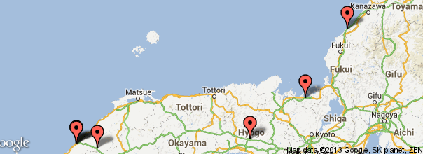
As an example, here are the maps for the twelve days of my Hokkaido trip earlier this month. (Click the first image to view them as a slideshow.)

You can see from these maps that my first day, riding from Hamada to Kanazawa, was a long ride with few stops. On the other hand, the ride from Otaru to Kutchan was overwhelmingly beautiful, and you can see that we stopped numerous times to appreciate the views. Using this data, I can fairly easily pinpoint the locations of all the photos I took with my DSLR, which does not have GPS data on its own.

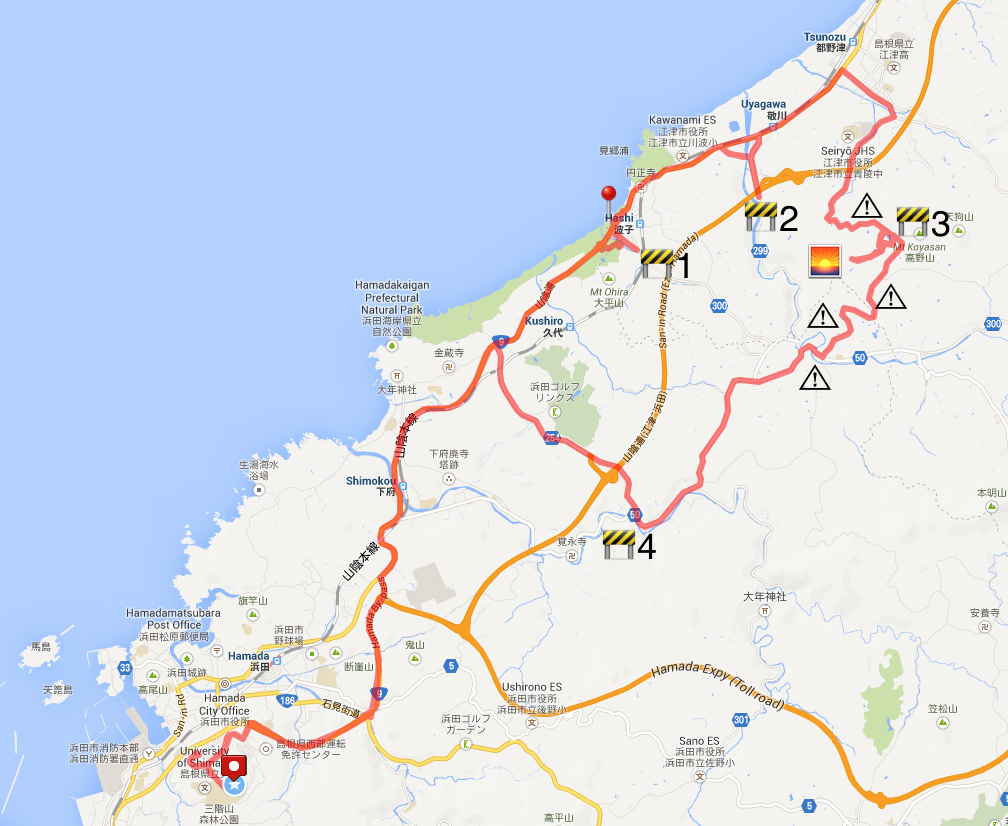
The daily log that gets uploaded to your Evernote account actually includes details for each stop. If the app knows the location, it will create a link to the location’s Google+ page. If it does not know the location, it will give you the route number and city, which may (or may not) successfully link to a Google map. Take my final day as an example:

Here you can see that my first location is set at 9:59 p.m. on the 14th. That would be the apps best guess at where I was staying that night. It seems to have selected a restaurant near my hotel, but close enough… The next stop is a convenience store, Lawson’s, where I stopped to use an ATM and to drain the water from my boots. (See The Long Ride Home for the full report on this rainy ride.) The next stop was at 12:15, when I stopped to get some gas at Dr. Drive. As I had been riding for seven hours in the rain at this point, my next stop was 20 minutes later in a McDonalds to get some food and warm up a bit. Miraculously, the rain stopped while I was warming my hands around a cup of McDonalds’ infamously nuclear hot coffee, so the last stop before home was on route 9 in Gotsu, where I stopped at ゴリラ酒 (“Gorilla Alcohol”) to get some beer so I could warm up with a shower beer when I got home. (It seems there is a website for everything these days…) By the way, the route 9 link above is a perfect example of how this app fails for unknown locations outside of the USA.

shower beer

My data for the day ends in Gotsu, as I did not really move from home after enjoying my shower beer.

So now that I’ve shown you how I use this to track my stops when riding, how would you make use of this app?

Disclaimer: If you plan on cheating on your spouse, murdering someone, or just participating in some anarchy, you might want to turn this app off. The author will not be held responsible if  you accidentally place yourself at the scene of a crime.

Roads Washed Out

Washed out ride map
Route Map. Click to enlarge for details.

We had quite a storm in Shimane a few days back, and there were a lot of landslides and flooding. We did not suffer any damage at our house, but the surrounding area is riddled with road closures and traffic due to road repairs. I have stayed off of the local roads for a few days, as I figured they would be rife with gravel & sand, and would not be safe for a motorcycle. However, the passing storm has brought about beautifully clear skies and pleasant weather, so today I gave in and risked the roads.

The Goal: Ride up route 9 to Aquas and purchase a souvenir/gift for a friend, then turn right into the mountains and find a roundabout way home.

The ride to Aquas was pretty straight forward, as there were no delays or road closings, but there were a number of landslides along the road that had already cleared up. The only hazard I faced along the way was a rather large book (yellow pages?) which was sitting in the right third of my lane on the bypass.

After picking up some stickers and crackers at the gift shop, I crossed the street from Aquas and took a photo with the iconic Aquas walking bridge (red pin on the map). The sky was beautiful, and a short ride down the road I found a spot on the beach where a couple of guys were enjoying some late afternoon wake boarding.

From Aquas I took the immediate right inland on the route 300 to Arifuku onsen. Unfortunately, I only made it about 500 meters before I met my first closed road. I turned back and continued up route 9 a bit further and tried again at route 299, only to find a second barrier to my return home. I was forced to backtrack and head back up route 9 again to route 297 towards Atoichi, and from their towards the Green Line into Kanagi. I was intentionally trying to avoid this road, as I love it and take it often and was hoping to find some new interesting paths through the mountains.

I was glad to see that I finally found a road that was open, but this path was rife with hazards. I only took photos of a few, but there were many collapse walls on the uphill side, and areas were the dowhill side of the road was washed out. It was a constant slalom of single lane traffic spots around blind corners, and it was a rather stressful ride.  The final photo below is of the eastern windmill access road, which is where I often go to take photos. Luckily the western access road was open and the sun was just starting to set.

I love riding these windmill access roads for a few reasons; the views are spectacular, the roads are new and well made, and there is never anybody else there. For these reasons, I find it a great place to ride and to take photos. This may be the first time I took photos on the western route, and I found myself glad that the eastern route was blocked.

Overall, it was a great day for a ride. Finding my way home past the closures and hazards was a fun challenge, and I think that I just may have captured a photo or two worth entering in the Hamada photo contest…